Public consultation on Exeter City Council’s proposals for the updated local plan, published as the Exeter Plan, closed on 19th December 2022. Using the Commonplace platform to encourage public engagement, key documents updated from the previous local plan were included at the foot of each section page.
Exeter City Council’s Vision 2040 document clearly states the Council’s intention to: “Protect the landscape’s rural character in close proximity to urban areas by resisting piecemeal urban expansion which undermine landscape patterns and sense of place.”
NATURAL ENVIRONMENT
> LANDSCAPE SETTING / Pinhoe and the Northern Hills
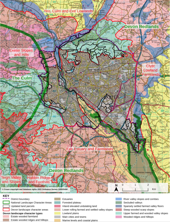
The Exeter Landscape Sensitivity Assessment (updated by White Consultants, August 2022 – full report here) appraises open countryside within and around Exeter, “demonstrating that much of the land around Exeter is of intrinsic landscape value”. The drawing below, included in the assessment, clearly shows the woodland environment from Stoke Woods and Huxham Brake reaching into the upper part of Pinhoe, specifically land adjacent to and including Higher Field.
These ‘land parcels’ were referred to in the Planning Inspector’s appeal refusal of development on Higher Field.
Land parcels are described according to a series of distinctive characteristics, special features and qualities which are ‘defined to support policy wording’.
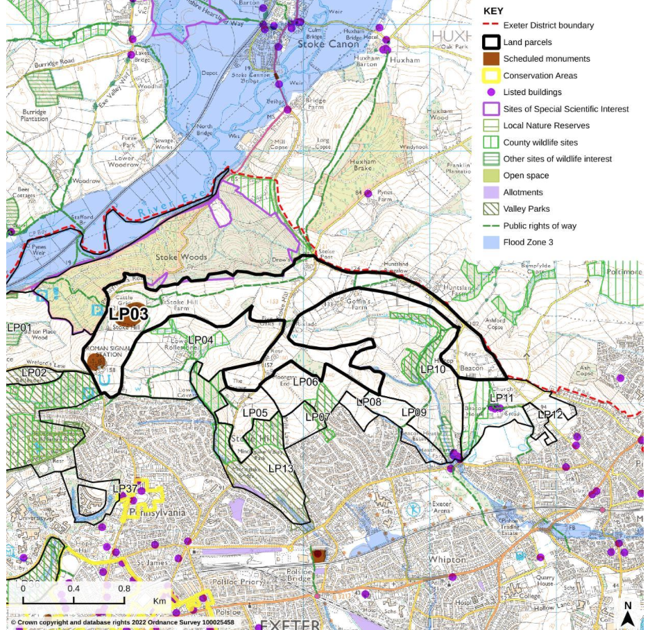
Land Parcels (LP) 3, 10 and 11 (including Pinhoe Church and across to Higher Field) are described as High sensitivity to housing. LP12 is High / Medium (reaching into the Pulling Rd development and the field opposite Higher Field which is subject to a recent planning application).
KEY TERMS as described in the Landscape Sensitivity Assessment:
Landscape value is the relative value that is attached to different landscapes by society.
Landscape sensitivity is the term applied to landscape character and the associated visual resource, combining judgements of their susceptibility to a specific development type and considered together with the (intrinsic) value related to the landscape and visual resource.
High/ medium sensitivity > Landscape and/or visual characteristics of the land parcel are vulnerable to change and/or its values are medium through to high (although this is not essential where landscape or visual susceptibility is a key issue). It may be able accommodate the relevant type of development but only in limited situations without significant change to character, special qualities and features or adverse effects. Thresholds for significant change are low.
High sensitivity > Landscape and/or visual characteristics of the land parcel are very vulnerable to change and/or its values are high or high/medium and it is unable to accommodate the relevant type of development without significant change to character, special qualities and features or adverse effects. Thresholds for significant change are very low.
Report Conclusions:
In studying these landscapes in detail it is suggested that the following distinctive characteristics, special features and qualities make this valued landscape sensitive to change. Proposed developments should be assessed against the following:
• Protect and conserve the strategic landscape setting of, and backcloth to, the city and where possible enhance it.
• Avoid prominent ridges and slopes and, in particular, steeper slopes.
• Protect, conserve and enhance the existing treed and open undeveloped skylines.
• Avoid breaching skylines with development form, keeping roof lines well below skylines formed by vegetation or landform.
• Conserve and enhance the river valley corridors, their floodplains and their settings including the Exe and the Clyst.
• Protect important views to and from the hills surrounding the city of Exeter.
• Protect the landscape’s rural character in close proximity to urban areas by resisting piecemeal urban expansion which undermine landscape patterns and sense of place.
• Protect the character of rural lanes, minimising road widening and signage in association with new development.
• Protect and appropriately manage nationally important historic/ archaeological sites and provide interpretation where appropriate.
• Plan for a network of green spaces and green infrastructure links to support the current and future population of Exeter whilst integrating new development into the landscape.