Langaton Lane: experimental order

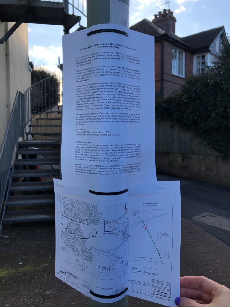
Posted in the village on Friday 4th March, Devon County Council have announced their Experimental Order for the closure of Langaton Lane to through traffic:

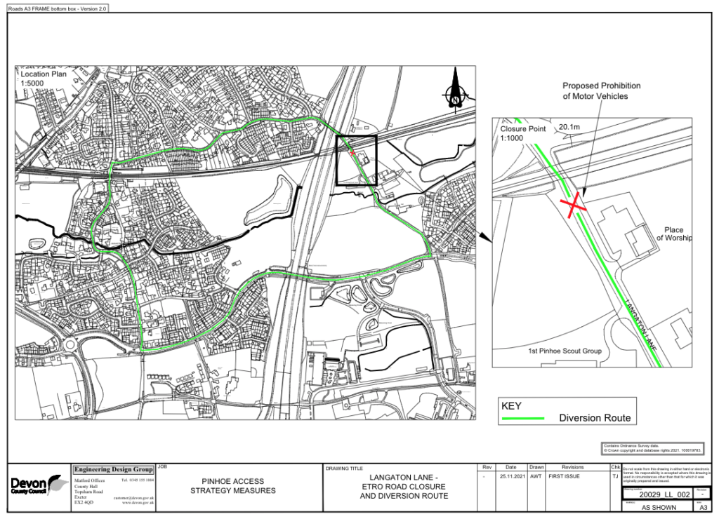
“The purpose of this scheme is to create a green lane on Langaton Lane by introducing a point closure south of the Railway bridge. A green lane is a type of street that allows for walking and cycling but prevents motorised through-traffic.
Recently E.ON have had the road closed temporarily for work on underground services. This has illustrated the benefits of removing rat-running traffic from Langaton Lane. The Lane will be quieter for all, and a pleasant environment for pedestrians and cyclists to use. Vehicle access to properties and land beside the Lane will still be available, but only from one direction.”

Green Lanes prioritise pedestrians and cyclists, which is a welcome approach to this important route to Pinhoe’s Scout Hut and our community field. However, there is no mention of the resilience route that Langaton Lane provides for vehicular traffic travelling through Pinhoe.

DCC: Langaton Lane Diversion Route

DCC info: Why is this being proposed?
“Langaton Lane is a relatively narrow lane, limiting two way traffic in places with no footways east of the motorway bridge. The 1st Pinhoe Scout Group, Pinhoe Target Shooting club, a meeting place for the Plymouth Brethren, WPD station, two residential properties and a storage facility for fairground equipment are situated on the lane. The lane is surrounded by planned residential and employment development in the East of Exeter Growth Point.
In its current form,  Langaton Lane is unsuitable for a significant amount of additional traffic. The lack of facilities for people walking or cycling, or people with mobility assisted vehicles is also a concern, and a future situation with higher pedestrian and vehicular traffic levels without improved pedestrian facilities is likely to lead to a worsening of road safety.
Creating a green lane on Langaton Lane (allowing walking and cycling but no through traffic) is identified in the Exeter Transport Strategy, following a recommendation to include green lanes as agreed at the Scrutiny Committee meeting which was held in June 2020. This would provide an attractive active travel link for Pinhoe residents to access employment at the Science Park, Cranbrook and also the future planned Clyst Valley Trail.

During recent months (June 2021 – March 2022) Langaton Lane has been closed under a TTRO for works to services. The temporary closure has been well received locally and requests have been made by members of the public to move to a permanent closure of the lane. In order to identify the support for this scheme, and to test out the access, an ETRO would allow these to be trialled before introducing a permanent change.”

Relevant webpage click HERE: there is also info on the Devon County site about their Doing What Matters scheme which has been identified as applicable to Langaton Lane: https://www.devon.gov.uk/doingwhatmatters/


NOTE: in his reply to a request for clarity regarding changes to DCC traffic strategy for Pinhoe (17NOV21) William Pratt referred to “a new crossing near Parkers Cross Lane, which I believe is the most popular new infrastructure proposal in the recent survey.” County Councillor Tracy Adams canvassed opinions from residents near to Langaton Lane (no public info available) and no access has been granted to information regarding the survey mentioned / 18th November 2021

LIDL STORE APPROVED

Despite 70 public objections and safety concerns about adjoining highways infrastructure, this new supermarket development was unanimously supported by the City Council planning committee on Monday 21st February 2022

Exeter City Council Planning Committee Political Balance (source: Exeter City Council)

Cllrs Rachel Sutton (Exwick) and Keith Sparkes (Topsham) thought it would be “good for Pinhoe”. Cllr Duncan Wood (Pinhoe) represented local residents’ views and his own lived experience living near to the development; however he was unable to provide technical evidence or data as requested by Council leader Phil Bialyk. There were no representations by local residents, nor by Pinhoe’s county councillor with responsibility for Highways.

Summary Concerns

Pedestrian access is restricted to a narrow pavement along this busy main road, especially now Aldi have built right up to the pavement and removed their green planting. Walking single file makes it difficult to navigate safely with children, prams, buggies or walking the dog.

Traffic congestion is already a problem at Venny Bridge. There are multiple safety concerns and major infrastructure problems at Chancel Lane Bridge, already known by Devon County Council and Highways.

Planning Committee Discussion

Highways approved the provision of two additional toucan crossings to prioritise cyclists and pedestrians; they agreed the plans as an “acceptable solution”. Noting the expected increase in traffic, estimated at 10% by 2024, would not have “a severe effect”, Highways did not remark on the impact of traffic on adjoining routes.

Despite cumulative queuing from multiple traffic lights in short succession, Exeter Council officers advised that air pollution would have minimal impact on local residents as “pollution dissipates very quickly”; the new housing development immediately opposite the Lidl site was not discussed. There was no mention of the effects of localised air pollution for cyclists or pedestrians. There was no discussion of site enhancements or public amenities, nor investment opportunities for critical infrastructure protection or safeguards

AN OPPORTUNITY TO REIMAGINE THIS AREA >

• extending the pavement along Aldi by reducing two lanes of traffic into a single lane, creating wide, accessible, safe connection between retail sites and all residential areas – from Hill Barton and Whipton, Summerway and Pinhoe

• street trees along Cumberland Way right up to Lidl’s doors, to make walking and cycling more enjoyable

• a new plan for Pin Brook to upgrade blue infrastructure to the rear and side of this site

• enhancing Pinhoe’s Trading Estate to reconfigure access routes and revive this business area, attracting local investment

Commercial, public and strategic infrastructure require long term planning including consultation and local trust in community engagement to create these opportunities

Let’s get some air pollution monitors in Pinhoe!


In a public statement, Pinhoe’s Labour City Councillor Duncan Wood confirmed:

“This is a vastly improved proposal than that presented in 2019 and Lidl has listened to some of our feedback whilst still firmly focused on building on this site. I spoke of the inappropriate location, remaining reservations about the junction, flooding implications and Chancel Lane Bridge. Also challenged the assumptions around sustainable travel to it by bus or walking for obvious reasons. Members listened and asked further questions but ultimately followed Officers recommendations and approved the application. It will certainly be good to see the junction improved as a result.”

JOIN THE MOVEMENT!

Objecting to housing development proposed on farm land above Mincinglake Valley Park

Photo by Francis Hallam, Saturday 20th November

Plans have been submitted to the City Council for a large development of 150 new homes and facilities on farm land next to the barn adjacent to Mincinglake Park. This greenfield site is an important gateway to the Northern Hills and the network of Valley Parks, used and loved by people across the city and a vital nature corridor for wildlife as part of our city’s green skyline.

Thanks to advice from a planning specialist, local groups of residents have been able to confirm this application is contrary to policies in Exeter’s Local Plan and against national planning policies. This site is not allocated in the current Core Strategy and is a greenfield site in a protected area. 

We urge you to join our protest by submitting your personal objection to the City Council

To object please consider using the information below. It is important that you include your own personal introduction. You will need to register on the Exeter Council Planning Portal https://exeter.gov.uk/planning-services/permissions-and-applications/find-and-comment-on-a-planning-application/how-to-make-a-comment/  and use the reference 21/1291/OUT or you can email your objection directly to case officer Matthew.diamond@exeter.gov.uk  quoting the same planning reference 21/1291/OUT

We believe this application  should be opposed on the grounds of: 

LANDSCAPE – this application represents significant harm to the landscape and is contrary to saved landscape in Local Plan Policy H1 (thanks to Naima Allcock for this update) and policy CP 16 of the Core Strategy which protects the Northern Hills and their link to the Valley Parks. 
The Northern Hills have long been regarded as marking the boundary of the city and have been protected by all previous versions of the Exeter Local Plan. They are a very distinctive feature which are locally designated. Building on these hills will have a significant effect on the wider landscape, visible from other areas of Exeter

PROTECTED SPECIES – this application risks significant harm to protected species such as bats,  dormice and newts, with insufficient  alternative habitats proposed for them contrary to paragraph 180 of the National Planning Policy Framework. The developer has suggested that the detail of providing alternative habitat to later. However there has been insufficient assessment of sites

LOCAL IMPACT– this site provides an important link from Mincinglake to the Northern Hills as part of the unique green landscape in the North of the city. The application represents loss of recreational space and is contrary to policy CP16 of the Core Strategy. In addition, building on the boundary of the park will have a detrimental effect as an “alternative natural greenspace”. Any amount of levy would be of no consequence if the park it is supposed to enhance is seriously harmed

HIGHWAYS – this car-led proposal is some distance from larger shops, schools and other facilities, risking serious harm to pedestrians, cyclists and horse riders using the very narrow Stoke Hill Road due to significantly increased numbers of vehicles using the proposed access north of Mincinglake Bridge . This would be contrary to paragraph 112 of the National Planning policy framework

AIR QUALITY– any increase in the number of cars using the Stoke Hill roundabout would have a significant detrimental effect on the health of pedestrians and cyclists as well as residents living close to it, due to increased congestion. This is contrary to policy CP 11 of the Core Strategy

LAND CONTAMINATION – there is clear evidence of contaminated land in the application area. If not dealt with correctly this could lead to contamination of waterways or ground water within the important wildlife area of the Valley Park